The Potomac Heritage Trail Association (PHTA), a 501(c)3 organization founded in 2005, is the only volunteer group supporting the entire Potomac Heritage National Scenic Trail (PHNST). Its comments on the PHNST Comprehensive Plan begin with the eight questions, followed by PHTA conclusions.
Topic Questions 1-8:
1. What opportunities do you see for partnerships to improve communication, connectivity, stewardship, and programming?
The PHNST is a project of national significance (that’s what the “N” stands for!) and follows a major river that runs hundreds of miles (that’s what the “P” stands for!). But the land managers often don’t communicate, and act as if it begins and ends within their boundaries. Examples:
- Long-term decisions on the PHNST route can be unduly swayed by short-term events, such as a budget cut to maintenance staff. Yes, PHNST route planning must consider large-scale affordability (see Answer #7), but not at the level of individual staffing.
- Absurdly, one can follow the PHNST in the Leesburg area and reach a segment where bikes are allowed but not horses (Town of Leesburg), then where horses are allowed but not bikes (NoVa Parks), and then where bikes are allowed but not horses (Town of Leesburg). Loudoun County, to its credit, allows all nonmotorized user groups on the PHNST, but (perhaps due to lack of communication) did not reach such an agreement with the Town of Leesburg while providing substantial financial support to an upgrade of its PHNST route at Veterans Park.
- Absurdly, you can park at Leesylvania State Park, take a car shuttle to another PHNST trailhead (say, Powells Creek), hike back but be barred from reentering Leesylvania to retrieve your car. Why? The park closes to cars AND HIKERS when the parking lot fills up! Allowing the hiker back to his/her car to drive away would RELIEVE the parking shortage, but the park’s action EXACERBATES it. The PHNST should not be closed.
- A Catch-22 situation arises when a park manager (at HFNHP) cited lack of parking in suggesting the PHNST be excluded from their lands, even though parking could be built outside the park—but why build parking if there is no trail? The solution is to route the PHNST in conformance with the broader public interest. Whichever is built first (trail or parking) can cite plans for the other so building both in either order makes sense. Sometimes the parochial interests of the local land managers must be overridden.
- The various land managers should collaborate with each other, and work for the good of the public and of the PHNST. A utopian idea, perhaps, but we should try.
2. Where are the most important gaps or missing connections (on land or water) that limit access today?
PHTA has provided extensive research in Loudoun, north Fairfax, south Fairfax, and Prince William. Feasibility studies have provided useful ideas on filling PHNST gaps in:
- McLean (Kimley Horn 2019)
- Lorton (Toole Design)
- Powells Creek boardwalk 2024
Letters of support for particular routes in PHNST gaps include: - US Reps. Wexton/Connolly 2024
- US Reps. Subramanyan 2026
- State Sen. Boysko 2024
- Supv. Foust 2022
In Prince Georges County, MD, there is a very interesting recent proposal to extend the PHNST from National Harbor south through the new Notley Hall development to Fort Foote Park. The National Park Service should respond favorably.
3. What natural, cultural, or historic resources along the corridor need heightened protection, and what changes would help?
Protect all of them against data centers, housing tracts, ATVs, and shopping malls, but no “protection” is needed from trail users. Most public areas (e.g., Great Falls Park, the C&O, and the Mount Vernon residence) have achieved a good balance over the past decades by allowing visitors access to most such resources, with fences or signage where needed. Only a very few (e.g., Native American art on rocks) are entirely off limits.
4. How can we balance high-quality recreation with resource stewardship?
See Answer #3. In recent years attempts have been made to expand broadly the type of resources for which trails would be sharply restricted (e.g., near historic ruins or in flood plains). Such efforts are misguided. As in Answer #3, the trail-friendly balance from earlier decades (say, 1960s – 2000s) is correct.
Too often, when protecting a natural resource, say a wetland, the land manager says “no trail” without balancing the connectivity gain. There is almost always a mitigation, such as rerouting, signage or fencing. The rarer the natural resource, perhaps, the more extensive the mitigation for a trail might be. Always we need to keep in mind the national significance of the Potomac Heritage National Scenic Trail.
5. What safety concerns most affect your experience today?
In recent years, efforts have been made to prohibit trails where there is no regular police presence, or no quick access for first responders. But in earlier decades (again, 1960s through 2000s) remote trails were favored, not discouraged. As in Answers #3 and #4, the earlier consensus remains correct.
6. What stories should the trail tell more clearly, and where?
The PHNST should highlight the area’s rich heritage and its world-class scenic value—that’s what the “H” and the “S” stand for. But it cannot do so unless it actually is a trail, not a line on a map. That’s what the “T” stands for! The PHNST must be completed in reasonable time (think years, not decades), or it will have no
stories to tell.
Land acquisition can be the toughest, most time-consuming, expensive and riskiest part of trail building. The PHNST route should be chosen so that land acquisition is made as feasible as possible. The sheer number of properties to acquire should be small, but in planning, other acquisition factors matter: some might be relatively easier (e.g., in flood plains, or far from owner’s view, or owned by a civic-minded corporation), or relatively harder (visible from or near to owner’s home).
Need for acquisition can be reduced by use of non-park public areas, such as (1) low speed, low traffic (especially unpaved) roads, (2) discontinued (but still public) roads, and (3) roadway right of way significantly wider than the road (Figure 1 shows the connectivity benefits in Western Loudoun of all three, respectively, in blue, turquoise and green). Careful consideration of all these factors in planning a PHNST route can be the difference between a ribbon-cutting in a few years, or a quagmire that’s left on the shelf for decades.
So yes, the PHNST should tell stories, which can only be told when it graduates from a plan to an actual trail.
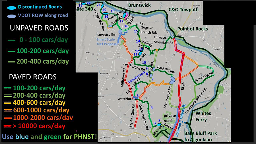
Figure 1: Connectivity provided by three types of non-park public lands in Western Loudoun
(shown in blue, turquoise, and green); good trail routes are in these colors
8. How can signage, maps, and digital tools better help people understand where the trail goes and what to expect?
These tools are useful but traditionally have suffered from land managers “thinking within their boundaries” (see Answer #1): only destinations within a particular park are signed, even though the trail goes far beyond. Twenty years ago, PHTA recognized this limitation and worked with some land managers (particularly, NoVa Parks and Loudoun Parks) to remedy it.
For instance, we paid for and posted handmade signs at Algonkian Park (NoVa Parks) that indicated the PHNST reaches Riverbend Park (Fairfax Co. Park Authority) in 9 miles and Great Falls Park in 11 miles. PHTA continues to post such signs widely, mostly in Northern Virginia, at our expense, where requested by the land manager. Now, with the Comprehensive Plan, there is a chance to sign the PHNST (physically and digitally) on a less ad-hoc, more systematic basis. Trail users will appreciate it.
ADDITIONAL PHTA COMMENTS
BENEFITS OF THE PHNST
In 2022 the Northern VA Regional Commission (NVRC) estimated the benefits of the PHNST in Northern Virginia (in terms of jobs, transportation and health) at $494 million every year. The benefits will be far higher once the trail is completed. In considering what costs are reasonable when planning for PHNST routes, we must always keep the benefits in mind.
THE POWER OF VOLUNTEERS
Volunteers can be very helpful in building and maintaining natural surface trails. There are several active volunteer groups such as Mid-Atlantic Off-Road Enthusiasts (MORE) and the Potomac Appalachian Trail Club (PATC). Loudoun County PCRS’s volunteer program builds about a mile of new trail every month. It serves as an exemplar to other localities.
PROFESSIONAL LIGHT-ON-THE-LAND TRAIL BUILDERS
Several organizations can provide affordable construction of light-on-the-land trails that meet professional standards regarding erosion control, respect for possible artifacts, etc. These include firms like Fina Trails, Tri-State, and others. The NPS works closely with the Student Conservation Association to build affordable trails; most recently (winter 2026) they constructed a rock ford across Pimmit Run in McLean, VA, and a rock stairway, to fill a gap in the PHNST. The cost per mile can be hundreds of times less than for a traditional shared use path.
COMPARING DIFFERENT POSSIBLE PHNST ROUTES
The Potomac Heritage Trail Association has done extensive research on possible routes for the PHNST, weighing such factors as:
- Scenic value
- Cultural value
- Minimizing cost
- Minimizing land acquisition
- Minimizing time to complete
- Accessibility and Multiuse
- Connectivity with other trails
In some cases (e.g., the C&O Canal Towpath) a trail route does well on all of these, so its value as a PHNST segment is obvious.
But what if there are several alternate routes that score differently on the various factors? Declaring an overall “best” route is subjective. When evaluating routes, the PHTA found it useful to make a table of how each route does on each factor, with green the best and red worst. For example, Table 1 evaluates three possible PHNST routes north of Leesburg and clearly shows one of these (in the rightmost column) outperforming the others (greenest). This type of comparison could be useful up and down the PHNST corridor.
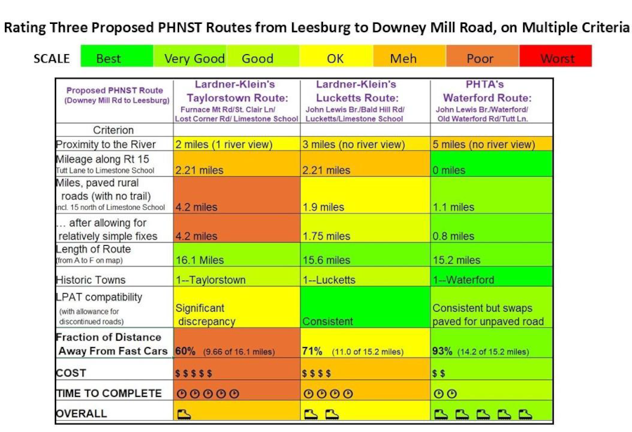
Table 1: Comparing various possible PHNST routes (columns) on various criteria (rows)
THE PHNST IS A NATIONAL SCENIC TRAIL—MAKE IT SO!
We must always keep uppermost in mind that the PHNST is a National Scenic Trail. The 1968 National Trails System Act defines National Scenic Trails as “extended trails, so located as to provide for maximum outdoor recreation potential and for the conservation and enjoyment of the nationally significant scenic, historic, natural, and cultural qualities of the areas through which such trails may pass.” A National Scenic Trail user may expect to face rugged terrain and be rewarded with world-class scenic views. Sucking truck exhaust is not part of the plan and should be tolerated only as a last resort. This sentiment was recently echoed by US Congress members who represent the PHNST in Northern Virginia.
US Representatives Gerry Connolly (VA11) and Jennifer Wexton (VA10), in their August 6, 2024, letter, state that “Inside or outside National Parks, the PHNST should follow as scenic a route as possible and be separated from heavy traffic as much as possible.” In his January 15, 2026, letter, US Representative Suhas Subramanyan agreed: “The PHNST should follow as scenic of a route as possible and provide hikers with safe recreation away from heavy traffic.”
SUMMARY: PHTA INPUT TO PHNST COMPREHENSIVE PLAN
- Resist recent misguided efforts to restrict trails for various reasons (flood plains, ruins, lack of police) (see Answers #3,4,5). The trail-friendly consensus from 1960s-2000s gets it right and still works.
- Route the PHNST along busy fast roads only as a last resort
- Route the PHNST along smaller paved roads/sidewalks only if an offroad route is unavailable.
- Plan for volunteers to help
- Plan for the opportunity for affordable professionally built trails by the SCA or private firms like Fina Trails and Tri-State.
- “Big Bucks” affordability SHOULD matter in route planning (e.g., don’t pick a route needing massive land acquisition—it will never happen)
- “Small Bucks” affordability SHOULD NOT matter in route planning (e.g., a budget cut to a maintenance staffer should not affect the PHNST route)
- The route should:
– (“P” in PHNST) feature views of the Potomac where possible
– (“H” in PHNST) showcase the area’s rich heritage
– (“N” in PHNST) be so great that people will come to visit from across the nation
– (“S” in PHNST) feature world-class scenery
– (“T” in PHNST) most importantly be a trail, not a line on a map.