The Department of Parks and Recreation has provided informative answers to specific questions posed by the Trails and Blueways Council (TBC) regarding the draft of the 10-year Countywide Trails Master Plan.
Draft plan will be discussed further at the May 26 TBC meeting. Meetings are hybrid; members of the public can attend in person or virtually.
1. What segments associated with three regional trails (Potomac Heritage National Scenic Trail, East Coast Greenway, and Bike Route 1) are not included in Tier 1, leaving them incomplete in 2035? (a map would be very helpful…)
- We are not committing to building all segments in Tier 1 by 2035, the cost would be upwards of $1B
- PHNST – The only segments left outside of Tier 1 are from the Town of Occoquan to Sea Ray Lane, The Town of Dumfries, and Gap 3.
- USBR1 – West of Dumfries Rd
2. What planned & proposed segments will become part of the National Capital Trails Network?
Likely only the Shared Use Paths, based on MWCOG’s selection criteria (8-10 ft wide, hard surface, continuous connection)
3. Where are bike/ped connections planned to connect to Fairfax County/NOVA Parks trails to match the Active Fairfax plan and at additional locations to establish a regional network? In particular, where is a connection planned:
a) downstream of Route 123 bridge
b) between Old Centreville Road and Splashdown Water Park to access I-66 trail in Fairfax County across Bull Run from Mayhew Sports Complex.
The only planned pedestrian only connection into Fairfax is with the Manassas Rail with Trail project. I don’t believe the ActiveFairfax plan includes pedestrian connections either. We will continue to evaluate these opportunities with Ffx Co and NoVa Parks
4. Which projects in Tier 1 will be prioritized for grant applications for NVTA 70% funding? Would any “recreational” trails quality, or just those designated “active mobility”?
NVTA 70% funding continues to focus primarily on congestion reduction which may limit recreational projects from scoring well. Here is a link to the NVTA page discussing the evaluation process and here is a breakdown of the percentage weight applied to various score criteria:
It will be an on-going effort once the TMP [Trails Master Plan] is adopted to review and evaluate the Tier 1 recreational and active mobility projects for potential funding eligibility including NVTA 70%.
5. Does county staff (Department of Parks and Recreation and PW Transportation Department) plan to submit budget requests each year for CIP so all Tier 1 projects in Pathways 2035 could be implemented in 10 years? If not, why not? (County.Executive―BOCS can always decline to propose funding for projects but IMHO the staff should always ask for the resources to implement an officially-adopted plan…)
We plan to develop proposals for specific segments. The amount of work that would go into creating 40+ proposals would overwhelm the planning team. Being targeted with our requests allows us to make a better case and to avoid drowning the Board in requests.
6. Will county staff propose that funding for Purchase of Development Rights also be used to simultaneously acquire right-of-way, on the parcels where trails are shown in Pathways 2035 plan?
We are working with the planning office on integrating PDR and Parks/Trails initiatives.
7. Since trails are for mobility as well as recreation, when will PW Transportation Department release a similar plan to close sidewalk gaps and establish integrated trails/sidewalk plan?
PWCDOT will continue to construct sidewalks with road projects and apply for local, state, and regional funding dollars to complete sidewalk gaps. Currently, PWCDOT is working on eight (8) active standalone sidewalk projects. Additionally, as GIS data becomes more available, I am also recommending that the next update the Mobility Chapter expand to include a proposed sidewalk network.
8. How will trail standards other than those in current DCSM (such as low water crossings) be formalized so zoning approvals will reference them? Will future changes in the trail standards be handled purely as an administrative process, without involving Planning Commission or BOCS? What DCSM changes and zoning code changes are appropriate to facilitate implementation of Pathways 2035?
The current DCSM sec 600 is currently being updated with new sections for common trails and will include notes to reference the Trail Standards Manual. There is an action item as Pathways 2035 to update the Trail Standards Manual, which could be turned into a new DCSM chapter. For developers, we will continue to include language that trail amenities are designed in consultation with DPR.
9. Does Pathways 2025 assume the current closure of Lake Manassas to recreational use is permanent, or does this long-range plan identify the potential for creating a Lake Manassas Blueway someday
The Broad Run Blueway terminates at Lake Manassas Dam. If the lake opens up, we will evaluate access points and portage opportunities
10. What outreach is planned for communities near Tier 1 projects so they are informed and, ideally, supportive of the new trails to be constructed nearby?
Outreach will be planned and conducted on a project-by-project basis
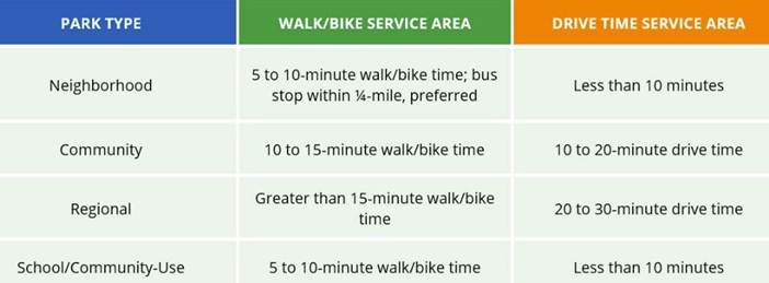
11. If all the trails in Tier 1 are completed, which additional communities would meet Level of Service standards established in Parks, Recreation and Tourism Chapter of 2040 Comprehensive Plan (below)?
This analysis hasn’t been completed yet, but will be