When Prince William County publishes the map of planned and proposed new trails in Pathways 2035, the 10-year Countywide Trails Master Plan, there will be some changes in the PHNST route.
The primary north-south route from the Occoquan River to Chopawamsic Creek was determined in coordination with the Northern Virginia Regional Commission and the National Park Service over the last year.
The most significant change will be the shift from the “old” route going west up Powells Creek into Montclair, then south via Waterway Drive into Prince William Forest Park.
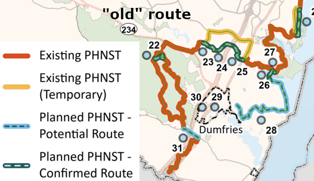
The new route will be a north-south path. The PHNST will go directly over Powells Creek rather than veer westward to Waterway Drive. The Pathways 2035 route, mimicking the route adopted by the Northern Virginia Regional Commission, will use the Powells Creek Crossing. That planned boardwalk/bridge will link Leesylvania State Park and Potomac Shores.
The trail in the Powells Creek Greenway, from Leesylvania State Park up Powells Creek to the county landfill, will stay included in the Mobility Chapter of the 2040 Comprehensive Plan. Various trail segments along Powells Creek will be included in one of the three tiers of priority defined in Pathways 2025.
That trail in the Powells Creek Greenway will be considered as a county-sponsored connection to the PHNST; no segments will be designated as an official “braid” of the PHNST. Designation could make a segment part of the official PHNST National Park Service unit, and there are few officially-designated braids on the PHNST..
One braided trail segment is in Prince William County near the Occoquan River. A PHNST bike route uses roads from Occoquan to Belmont Bay, while a separate walking route is planned closer to the Occoquan River.
Also, a trail connection to Cockpit Point Civil War Park could end up being designated as an official PHNST braid. Being an official part of the National Park Service unit might assist in obtaining funding someday for a bike/pedestrian bridge over the CSX railroad tracks.
Two revisions of the PHNST are planned at Prince William Forest Park. The north-south route passing through Dumfries will parallel Quantico Creek to go underneath I-95, then go south following the path used in 1781 by George Washington and the Compte de Rochambeau on their march to Yorktown. An archeological survey still needs to be completed to define the preferred route along the historic road trace from Van Buren Road to the visitor center, and then to Joplin Road.
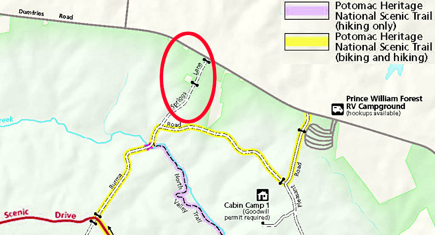
The current biking and hiking segments of the PHNST within Prince William Forest Park, west of the new north-south “spine,” will remain. The National Park Service will publish a new park map soon that revises where the PHNST connects to Route 234 (Dumfries Road). The new connection will be along the Spriggs Road entrance into the park, not at the RV campground.