The PHNST subcommittee of the Prince William County Trails and Blueways Council (TBC) met on May 20. Highlights include:
- Despite strong support in previous meetings by National Museum of the Marine Corps staff to route the PHNST so it would use the museum’s existing trails network, the museum’s board recently declared that the PHNST could not cross the museum grounds due to security concerns. East of I-95 from Gap 3 to Locust Shade Park, PHNST will have to go east on Joplin Road and then south on Route 1.
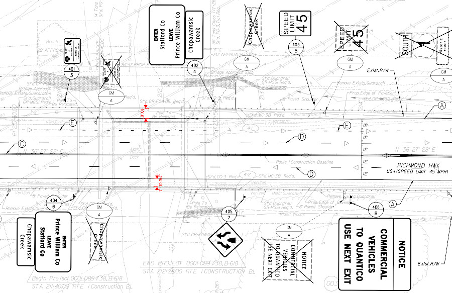
- Virginia Department of Transportation (VDOT) has started replacing the existing four-lane bridge on Route 1 over Chopawamsic Creek. The new bridge will include a paved shoulder to extend the PHNST into Stafford County (see below). Paved shoulder will be 10 feet wide on the southbound lanes, and between 7-10 feet wide on the northbound lanes.
- At 6:00pm on May 28, the National Park Service will host a virtual public meeting so the public can comment on the planned Comprehensive Plan for the PHNST.
- County staff is awaiting a new submission for the proposed rezoning for the Townes at Occoquan project (formerly known as Destination Place), REZ2024-00033. The new supervisor, Jeannie LaCroix, is familiar with the PHNST and has indicated support for the route proposed by TBC.
- Construction of the natural surface portion of the Featherstone segment of the PHNST has been completed. There is 200′ of boardwalk under construction now, and an additional 300′ of boardwalk to be completed in August after eagles finish nesting. South and north bridges have been delivered but are missing parts. Trail segment is expected to open in Fall 2026.
- Bids from contractors interested in the short extension of the Neabsco Boardwalk through the Julie Metz Wetland will be opened May 27. Multiple bidders have expressed interest in the project to upgrade existing natural surface trail to an elevated boardwalk.
- Prince William County Department of Parks and Recreation (DPR) plans to drop the PHNST designation from the segment of the Powells Creek Greenway trail that goes upstream from Leesylvania State Park through Montclair. The former plan for the PHNST headed west up Powells Creek. Pathways 2035 includes the north-south route using the Powells Creek Crossing. The most accurate planned route at the moment is displayed by the Northern Virginia Regional Commission.
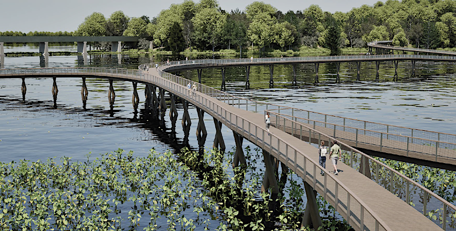
- Geotechnical boring equipment will be barged into Powells Creek next week to test the depth required for future Powells Creek Crossing pilings to reach bedrock. The project and its project manager are likely to transfer on July 1 from DPR to the new Department of Transportation and Capital Construction.
- Powells Creek Crossing, now close to 35% design stage (see concept above), is expected to cost around $15 million. The $9 million approved in 2019 bond issue will not be sufficient to build even a Phase 1 structure going all the way over Powells Creek between Leesylvania State Park to Potomac Shores.